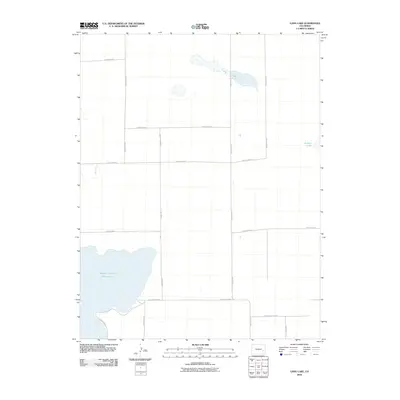
2010 Map of Long Lake
USGS Topo · Published 2010About this map
Adobe Creek Reservoir dominates the southwestern corner of this landscape, its expansive shoreline defining the local water management system in this part of Kiowa County. The terrain is characterized by a high-plains drainage network, where Colt Ditch and natural depressions like Long Lake and Potters Lake provided essential water storage for the surrounding agricultural tracts. The map reveals a strictly regulated section-line road system, with routes such as County Road H, County Road E, and County Hwy WW framing the wide-open geography. This grid pattern, punctuated by the occasional playa or seasonal lake, reflects the orderly settlement and ranching traditions of eastern Colorado at the start of the twenty-first century.
Find a feature on this map
18 named features on this map. Tap any name to fly to it.
Don’t see what you’re looking for? This feature index may not catch every label — zoom into the map to look around manually.
Map Details
Editions of this 2010 Long Lake Map
This is the sole edition of this map. No revisions or reprints were ever made.
Other maps of this area

1891 · Las Animas
USGS Topo · 1:125,000

1893 · Las Animas
USGS Topo · 1:125,000

1954 · Lamar
USGS Topo · 1:250,000

1955 · Tree Top Ranch
USGS Topo · 1:24,000

1955 · Mc Intosh Ranch
USGS Topo · 1:24,000

1955 · Bishop Ranch
USGS Topo · 1:24,000

1958 · Lamar
USGS Topo · 1:250,000

1974 · Haswell
USGS Topo · 1:24,000
1974 · Haswell SE
USGS Topo · 1:24,000

1974 · Arlington NE
USGS Topo · 1:24,000