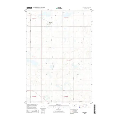
2015 Map of Long Lake
USGS Topo · Published 2015About this map
The small settlement of Long Lake serves as the focal point of this rural McPherson County landscape, situated along the intersection of Main St and 1st St S. The surrounding terrain is defined by a dense concentration of wetlands and small water bodies, including its namesake Long Lake and Klooz Lake, which dot the township divisions. Traces of early transportation routes are evident in the path of the Old Sioux Rd, which cuts across the northern sections of the survey area, reflecting a historic corridor through the Dakotas. The map provides significant genealogical value for the region, documenting several burial sites including Salem Cem just east of the village, Emmanuel Cem to the north, and Arena Valley Cem in the southern reaches. The gridded road network, including 106th St and 350th Ave, illustrates the organized agricultural partitioning of the Great Plains.
Find a feature on this map
29 named features on this map. Tap any name to fly to it.
Don’t see what you’re looking for? This feature index may not catch every label — zoom into the map to look around manually.
Map Details
Editions of this 2015 Long Lake Map
This is the sole edition of this map. No revisions or reprints were ever made.
Other maps of this area

1954 · Aberdeen
USGS Topo · 1:250,000

1956 · Aberdeen
USGS Topo · 1:250,000

1968 · Long Lake
USGS Topo · 1:24,000

1968 · Long Lake SE
USGS Topo · 1:24,000

1968 · Long Lake NW
USGS Topo · 1:24,000

1968 · Long Lake NE
USGS Topo · 1:24,000

1978 · Hosmer NE
USGS Topo · 1:24,000
1978 · Plainview Colony NE
USGS Topo · 1:24,000

1978 · Schumacher Lake
USGS Topo · 1:24,000

1978 · Plainview Colony NW
USGS Topo · 1:24,000