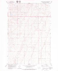
1978 Map of Plainview Colony NE
USGS Topo · Published 1979About this map
McPherson County's open prairie is mapped here during the late 1970s, defined by its agricultural layout and small-scale resource extraction. The landscape is marked by numerous Gravel Pits and a prominent Railroad Grade running across the northern sections, indicating the historical path of transport through this rural region. Recreational and communication infrastructure is concentrated near the roads, including the Leola Country Club, a Roadside Park, and a Radio Tower. The survey is particularly detailed in its depiction of property boundaries, utilizing fine dashed lines to show fence and field lines as they existed in 1973. This level of detail provides an excellent record of land use and rural development before modern shifts in farming practices changed the local topography.
Find a feature on this map
9 named features on this map. Tap any name to fly to it.
Don’t see what you’re looking for? This feature index may not catch every label — zoom into the map to look around manually.
Map Details
Editions of this 1978 Plainview Colony NE Map
This is the sole edition of this map. No revisions or reprints were ever made.
Other maps of this area

1899 · Ellendale
USGS Topo · 1:125,000

1954 · Aberdeen
USGS Topo · 1:250,000

1956 · Aberdeen
USGS Topo · 1:250,000

1968 · Long Lake
USGS Topo · 1:24,000

1968 · Long Lake SE
USGS Topo · 1:24,000

1968 · Forbes SW
USGS Topo · 1:24,000

1970 · Leola
USGS Topo · 1:24,000

1970 · Leola SW
USGS Topo · 1:24,000
1978 · Plainview Colony
USGS Topo · 1:24,000

1978 · Plainview Colony NW
USGS Topo · 1:24,000