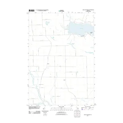
2011 Map of Long Lake West
USGS Topo · Published 2011About this map
Long Lake dominates the northeastern landscape of this Presque Isle County region, where the residential clusters of Leroy and Orchard Point sit along its western and southern shores. The area is characterized by a high density of small lakes and drainages, including Clinton Lake and Mindack Lake, which feed into the North Branch Thunder Bay River and the larger Thunder Bay River to the south. Historically significant corridors like the Long Lake Hwy and Trapp Lake Hwy connect the rural settlements of Bolton and Cathro. Local history researchers will find the Pilgrims Rest Cemetery situated near the river, a key landmark for tracing early families in this lake-strewn portion of Michigan. The grid of local roads, such as Dietz Rd and Cathro Rd, reflects the agricultural and residential development that has shaped the township's interior over the decades.
Find a feature on this map
61 named features on this map. Tap any name to fly to it.
Don’t see what you’re looking for? This feature index may not catch every label — zoom into the map to look around manually.
Map Details
Editions of this 2011 Long Lake West Map
This is the sole edition of this map. No revisions or reprints were ever made.
Other maps of this area

1954 · Alpena
USGS Topo · 1:250,000

1957 · Alpena
USGS Topo · 1:250,000

1958 · Alpena
USGS Topo · 1:250,000

1969 · Alpena
USGS Topo · 1:250,000

1971 · Lake Winyah
USGS Topo · 1:24,000
1971 · Presque Isle
USGS Topo · 1:24,000

1971 · Long Lake West
USGS Topo · 1:24,000

1971 · Alpena
USGS Topo · 1:24,000

1971 · Polaski
USGS Topo · 1:24,000
1971 · Thompsons Harbor
USGS Topo · 1:24,000