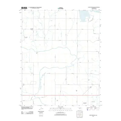
2012 Map of Long Mountain
USGS Topo · Published 2012About this map
Centerville and Lige anchor this rural Kiowa County landscape, where the agricultural grid is defined by a network of section line roads. The northeastern corner is dominated by the waters of the Tom Steed Reservoir and the adjacent Great Plains State Park, representing a significant modern hydraulic and recreational imprint on the land. Moving south, the terrain is shaped by the winding course of the N Fork Red River and its tributaries, including Owl Cr and Otter Cr. Notable topographical landmarks such as Dempsey Peak, Cable Mtn, and Long Mtn rise above the plains. For genealogists, the map identifies three distinct burial sites: Centerville Cem, Headrick Cem, and Rogers Cem. Transportation and aviation history are represented by the presence of Snyder Airport and the Pleasant Valley landing Strip, highlighting the region's reliance on both local airfields and traditional rural thoroughfares.
Find a feature on this map
38 named features on this map. Tap any name to fly to it.
Don’t see what you’re looking for? This feature index may not catch every label — zoom into the map to look around manually.
Map Details
Editions of this 2012 Long Mountain Map
This is the sole edition of this map. No revisions or reprints were ever made.
Other maps of this area

1949 · Cooperton
USGS Topo · 1:62,500

1950 · Snyder
USGS Topo · 1:62,500

1955 · Lawton
USGS Topo · 1:250,000

1956 · Glen Mountains
USGS Topo · 1:24,000

1956 · Manitou
USGS Topo · 1:24,000

1956 · Snyder
USGS Topo · 1:24,000

1956 · Snyder
USGS Topo · 1:62,500

1956 · Cooperton
USGS Topo · 1:62,500

1964 · Tipton SE
USGS Topo · 1:24,000

1964 · Tipton
USGS Topo · 1:24,000