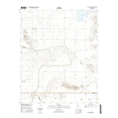
2016 Map of Long Mountain
USGS Topo · Published 2016About this map
The North Fork Red River snakes across this southwestern Oklahoma landscape, defining the jagged boundary between Kiowa, Jackson, and Tillman counties. The terrain is marked by significant elevations such as Dempsey Peak, Cable Mtn, and the titular Long Mountain, which rise above the surrounding plains. The settlement of Centerville and the smaller locality of Lige anchor the rural road network, which is primarily composed of numbered section-line roads. Genealogists will find several burial sites preserved on this sheet, including Centerville Cem, Headrick Cem, and Rogers Cem. To the north, the waters of Tom Steed Reservoir introduce a managed water feature that contrasts with the seasonal drainage of Owl Cr and Otter Cr. Aviation footprints are also visible with both Pleasant Valley Airport and Snyder Airport situated in the southern portion of the quadrangle.
Find a feature on this map
39 named features on this map. Tap any name to fly to it.
Don’t see what you’re looking for? This feature index may not catch every label — zoom into the map to look around manually.
Map Details
Editions of this 2016 Long Mountain Map
This is the sole edition of this map. No revisions or reprints were ever made.
Other maps of this area

1949 · Cooperton
USGS Topo · 1:62,500

1950 · Snyder
USGS Topo · 1:62,500

1955 · Lawton
USGS Topo · 1:250,000

1956 · Glen Mountains
USGS Topo · 1:24,000

1956 · Manitou
USGS Topo · 1:24,000

1956 · Snyder
USGS Topo · 1:24,000

1956 · Snyder
USGS Topo · 1:62,500

1956 · Cooperton
USGS Topo · 1:62,500

1964 · Tipton SE
USGS Topo · 1:24,000

1964 · Tipton
USGS Topo · 1:24,000