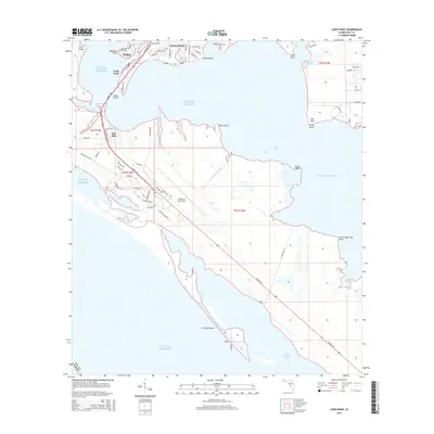
2015 Map of Long Point
USGS Topo · Published 2015About this map
Tyndall Air Force Base dominates this coastal landscape along the Gulf of Mexico, serving as a massive military installation that defines the development of the peninsula. The map captures the meeting of the Intracoastal Waterway and East Bay, where maritime activity and air force operations intersect. Along the northern shoreline, the residential areas of Parker and Callaway are separated by the waters of Pitts Bayou and Emmons Bayou. The landscape is a complex network of coastal inlets and points, such as Long Point and Laird Point, which frame the strategic DuPont Bridge crossing. To the south, the barrier landforms like Crooked Island protect Saint Andrew Sound, showing the delicate natural geography that surrounds this critical defense hub. The presence of numerous residential streets in the northwest suggests the urban expansion of these Bay County communities toward the military reservation.
Find a feature on this map
74 named features on this map. Tap any name to fly to it.
Don’t see what you’re looking for? This feature index may not catch every label — zoom into the map to look around manually.
Map Details
Editions of this 2015 Long Point Map
This is the sole edition of this map. No revisions or reprints were ever made.
Other maps of this area

1943 · Beacon Beach
USGS Topo · 1:31,680

1943 · Panama City
USGS Topo · 1:31,680

1943 · Crooked Island
USGS Topo · 1:31,680

1944 · Beacon Hill
USGS Topo · 1:31,680

1944 · Long Point
USGS Topo · 1:31,680

1945 · Allanton
USGS Topo · 1:31,680

1945 · North Of Allanton
USGS Topo · 1:31,680
1945 · Parker
USGS Topo · 1:31,680

1947 · Allanton
USGS Topo · 1:25,000

1949 · Apalachicola
USGS Topo · 1:250,000