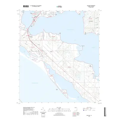
2018 Map of Long Point
USGS Topo · Published 2018About this map
Tyndall Air Force Base occupies a massive footprint on the peninsula between Saint Andrew Bay and East Bay, showcasing the military's strategic presence on the Florida Panhandle. The landscape is defined by an intricate network of waterways including Parker Bayou, Pitts Bayou, and Callaway Bayou, which carve into the residential areas of Parker and Callaway. The connection between the mainland and the base is established via the Dupont Bridge, a critical piece of infrastructure spanning the narrows near Pearl Bayou.
Find a feature on this map
78 named features on this map. Tap any name to fly to it.
Don’t see what you’re looking for? This feature index may not catch every label — zoom into the map to look around manually.
Map Details
Editions of this 2018 Long Point Map
This is the sole edition of this map. No revisions or reprints were ever made.
Other maps of this area

1943 · Beacon Beach
USGS Topo · 1:31,680

1943 · Panama City
USGS Topo · 1:31,680

1943 · Crooked Island
USGS Topo · 1:31,680

1944 · Beacon Hill
USGS Topo · 1:31,680

1944 · Long Point
USGS Topo · 1:31,680

1945 · Allanton
USGS Topo · 1:31,680

1945 · North Of Allanton
USGS Topo · 1:31,680
1945 · Parker
USGS Topo · 1:31,680

1947 · Allanton
USGS Topo · 1:25,000

1949 · Apalachicola
USGS Topo · 1:250,000