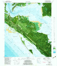
1982 Map of Long Point
USGS Topo · Published 1983About this map
Tyndall Air Force Base dominates this coastal landscape, sprawling across the peninsula between East Bay and St Andrew Sound. The 1982 survey reveals a complex military installation featuring the Tyndall School, a control tower, and specialized water features like Big Ammo Lake and Little Ammo Lake. To the northwest, the residential and civic boundaries of Parker and Callaway meet near the water, while smaller settlements like San Blas and Britton line the highway corridors.
Find a feature on this map
47 named features on this map. Tap any name to fly to it.
Don’t see what you’re looking for? This feature index may not catch every label — zoom into the map to look around manually.
Map Details
Editions of this 1982 Long Point Map
This is the sole edition of this map. No revisions or reprints were ever made.
Other maps of this area

1943 · Beacon Beach
USGS Topo · 1:31,680

1943 · Panama City
USGS Topo · 1:31,680

1943 · Crooked Island
USGS Topo · 1:31,680

1944 · Beacon Hill
USGS Topo · 1:31,680

1944 · Long Point
USGS Topo · 1:31,680

1945 · Allanton
USGS Topo · 1:31,680

1945 · North Of Allanton
USGS Topo · 1:31,680
1945 · Parker
USGS Topo · 1:31,680

1947 · Allanton
USGS Topo · 1:25,000

1949 · Apalachicola
USGS Topo · 1:250,000