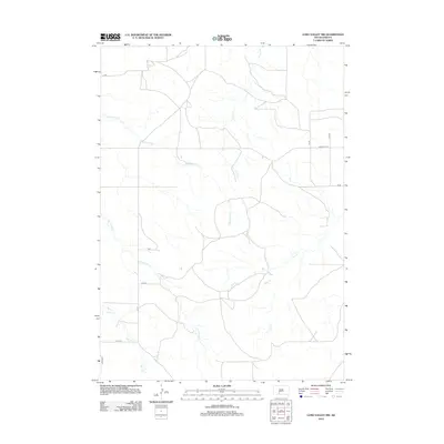
2012 Map of Long Valley NW
USGS Topo · Published 2012About this map
Waterhole Cr and Corn Cr dominate this rural landscape in the southwestern corner of South Dakota, where the topography is defined by a dendritic network of drainages. The map reveals a sparsely populated ranching or agricultural region near the turn of the 21st century, structured by a grid of section line roads such as CS 66 and Co Hwy Ch 16. The seasonal nature of the western plains is evident in the naming of several intermittent waterways, including Dry Cr and Lost Turkey Cr, which carve shallow valleys through the terrain. Further south, Bull Cr and Fish Cr to the north provide further evidence of the localized watershed patterns that have long dictated movement and settlement in Bennett County.
Find a feature on this map
16 named features on this map. Tap any name to fly to it.
Don’t see what you’re looking for? This feature index may not catch every label — zoom into the map to look around manually.
Map Details
Editions of this 2012 Long Valley NW Map
This is the sole edition of this map. No revisions or reprints were ever made.
Other maps of this area

1955 · Martin
USGS Topo · 1:250,000

1958 · Martin
USGS Topo · 1:250,000

1969 · Norris
USGS Topo · 1:24,000

1969 · Eagle Mans Butte
USGS Topo · 1:24,000

1980 · Kadoka
USGS Topo · 1:100,000

1981 · Cedar Butte
USGS Topo · 1:25,000

1981 · Long Valley
USGS Topo · 1:25,000

1981 · Blackpipe
USGS Topo · 1:25,000
1981 · Short Bow Creek
USGS Topo · 1:25,000

1983 · Martin
USGS Topo · 1:100,000