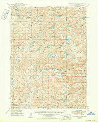
1950 Map of Longfellow Lake
USGS Topo · Published 1950About this map
Longfellow Lake and a dense network of smaller basins characterize this corner of the Nebraska Sandhills, where dozens of named valleys and shallow lakes occupy the depressions between dunes. The landscape in the mid-20th century was defined by a scattered ranching infrastructure, evidenced by numerous numbered schoolhouses such as School No 22 and School No 32 serving the remote population. The southwestern portion of the sheet includes part of the Crescent Lake National Wildlife Refuge, highlighting the region's importance for migratory birds and water resources in an arid environment. Topographical features like Wild Horse Flats and Hog Valley suggest a heritage of livestock and wildlife, while specific sites like Dipping Vat Lake point to the practical necessities of the early cattle industry. The presence of multiple lakes named for individuals, including R Kincaid Lake and Mar Lake, provides a record of early landholders across the Garden and Grant county line.
Find a feature on this map
61 named features on this map. Tap any name to fly to it.
Don’t see what you’re looking for? This feature index may not catch every label — zoom into the map to look around manually.
Map Details
Editions of this 1950 Longfellow Lake Map
3 editions found

Other maps of this area

1948 · Ashby
USGS Topo · 1:62,500

1948 · Bingham
USGS Topo · 1:62,500

1948 · Lakeside
USGS Topo · 1:62,500

1948 · George Lake
USGS Topo · 1:62,500

1949 · Ashby
USGS Topo · 1:62,500

1949 · Mumper
USGS Topo · 1:62,500

1949 · Rackett
USGS Topo · 1:62,500

1950 · Velma
USGS Topo · 1:62,500

1950 · Crescent Lake
USGS Topo · 1:62,500

1950 · George Lake
USGS Topo · 1:62,500