
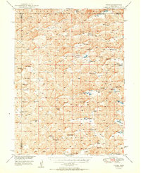
1950 Map of Velma
USGS Topo · Published 1950About this map
The Nebraska Sandhills ranching culture is well-defined across this mid-century survey of the Velma area, where three counties—Grant, Arthur, and Garden—converge. The landscape is characterized by a dense network of valley systems, including Voss Valley, Cranford Valley, and Benscoter Valley, which dictate the placement of the region’s expansive cattle operations. Named family holdings like the Beekins Ranch, Rothwell Ranch, and Starkey Ranch are prominent features, illustrating the generational land use that defined this part of the state following World War II.
Find a feature on this map
59 named features on this map. Tap any name to fly to it.
Don’t see what you’re looking for? This feature index may not catch every label — zoom into the map to look around manually.
Map Details
Editions of this 1950 Velma Map
2 editions found
Other maps of this area

1897 · Ogallala
USGS Topo · 1:125,000

1900 · Chappell
USGS Topo · 1:125,000

1900 · Ogallala
USGS Topo · 1:125,000

1948 · George Lake
USGS Topo · 1:62,500

1948 · Spring Valley
USGS Topo · 1:62,500

1949 · Arthur
USGS Topo · 1:62,500

1949 · Rackett
USGS Topo · 1:62,500

1950 · Spring Valley
USGS Topo · 1:62,500

1950 · George Lake
USGS Topo · 1:62,500

1950 · Arthur
USGS Topo · 1:62,500