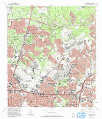
1992 Map of Longhorn
USGS Topo · Published 1993About this map
San Antonio International Airport anchors the southwestern portion of this landscape, marking a period of intense suburban and industrial expansion in northern San Antonio. The terrain is defined by the drainage systems of Salado Creek, Mud Creek, and Elm Creek, which wind through developing residential enclaves such as Hollywood Park, Hill Country Village, and Windcrest. While many areas show the grid of modern development, the map preserves older family and community markers, including the Classen, Friesenhahn, and Beitel Memorial cemeteries. The transition from rural to suburban is evident in the presence of the Texas Transportation Museum and Longhorn Siding alongside major infrastructure like the Wurzbach Parkway and North Loop Road. Schools like Madison High Sch and Douglas MacArthur High Sch serve as community hubs within this rapidly evolving corridor.
Find a feature on this map
55 named features on this map. Tap any name to fly to it.
Don’t see what you’re looking for? This feature index may not catch every label — zoom into the map to look around manually.
Map Details
Editions of this 1992 Longhorn Map
2 editions found
Other maps of this area

1953 · Otis Ridge
USGS Topo · 1:24,000

1953 · Schertz
USGS Topo · 1:24,000

1953 · San Antonio West
USGS Topo · 1:24,000

1953 · Bulverde
USGS Topo · 1:24,000

1953 · San Antonio East
USGS Topo · 1:24,000

1953 · Bat Cave
USGS Topo · 1:24,000

1953 · Longhorn
USGS Topo · 1:24,000

1953 · Castle Hills
USGS Topo · 1:24,000

1953 · Martinez
USGS Topo · 1:24,000

1954 · San Antonio
USGS Topo · 1:250,000