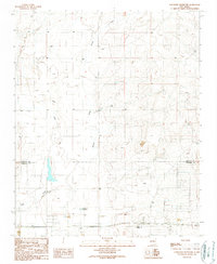
1990 Map of Longhorn Reservoir
USGS Topo · Published 1990About this map
Longhorn Reservoir sits at the heart of this landscape along the border of Santa Fe and Torrance counties. The terrain is defined by the drainage patterns of Salt Draw and Armijo Draw, which channel seasonal water through a series of shallow basins and tanks. This 1990 provisional map captures a transition in land use, where traditional ranching infrastructure like the Longhorn Ranch and various unnamed wells and water tanks coexist with modern additions such as a Trailer Park and a Radio Tower. For local historians, the inclusion of a solitary Grave north of the reservoir and the presence of Stinking Spring provide specific points of interest for tracing early settlement and natural landmarks in this part of New Mexico. Extensive Borrow Pit locations across the southern portion of the sheet indicate ongoing resource extraction or road maintenance during this era.
Find a feature on this map
14 named features on this map. Tap any name to fly to it.
Don’t see what you’re looking for? This feature index may not catch every label — zoom into the map to look around manually.
Map Details
Editions of this 1990 Longhorn Reservoir Map
This is the sole edition of this map. No revisions or reprints were ever made.
Other maps of this area

1892 · San Pedro
USGS Topo · 1:125,000

1894 · Lamy
USGS Topo · 1:125,000

1917 · Estancia
USGS Topo · 1:125,000

1954 · Santa Fe
USGS Topo · 1:250,000

1954 · Fort Sumner
USGS Topo · 1:250,000

1954 · Socorro
USGS Topo · 1:250,000

1956 · Edgewood
USGS Topo · 1:62,500

1956 · Estancia
USGS Topo · 1:62,500

1958 · Socorro
USGS Topo · 1:250,000

1958 · Fort Sumner
USGS Topo · 1:250,000