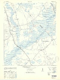
1953 Map of Longs
USGS Topo · Published 1953About this map
The Waccamaw River and Little River define this coastal Carolina landscape, where the border between North Carolina and South Carolina cuts through the dense wetlands of Cawcaw Swamp. The community of Longs serves as a central hub, connected by the Pireway Road to outlying settlements like Little Town and Olyphic. This 1953 publication reveals a rural infrastructure built around river crossings and timber, noted by the presence of an Old RR Grade and the Worthams Ferry crossing. For genealogists and local historians, the map is a dense record of mid-century community life, pinpointing several specific institutions such as the Deep Branch School, Buck Creek Church, and the dual-purpose Pleasant Plains Ch Waccamaw School. The landscape is etched with numerous named branches like Buck Creek and Cedar Branch, illustrating the complex drainage of the Simpson Creek area.
Find a feature on this map
46 named features on this map. Tap any name to fly to it.
Don’t see what you’re looking for? This feature index may not catch every label — zoom into the map to look around manually.
Map Details
Editions of this 1953 Longs Map
2 editions found

Other maps of this area

1937 · Nixonville
USGS Topo · 1:48,000

1942 · Nixonville
USGS Topo · 1:62,500

1943 · Little River
USGS Topo · 1:31,680

1943 · Pireway
USGS Topo · 1:31,680

1943 · Calabash
USGS Topo · 1:31,680

1943 · Wampee
USGS Topo · 1:24,000

1943 · Freeland
USGS Topo · 1:24,000

1944 · Longs
USGS Topo · 1:31,680

1949 · Georgetown
USGS Topo · 1:250,000
1953 · Little River
USGS Topo · 1:24,000