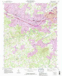
1993 Map of Longview
USGS Topo · Published 1996About this map
The industrial and residential growth along the Burke and Catawba County line is documented here in the early 1990s. The Southern railroad corridor serves as the spine for development, linking the settlements of Icard, Hildebran, and Longview. While the northern section of the map shows suburban expansion and infrastructure like the Municipal Airport and City Hall, the southern landscape remains defined by the winding course of the Henry River and its tributary, the Henry Fork. This area is dotted with small rural centers and numerous community landmarks, such as Advent Crossroads and the Mountain Grove Church near Baker Mtn. The detailed topographic data reveals the transition from the river lowlands to the rising elevations of Piney Mtn, offering a clear view of how the regional road network connects isolated farmsteads to emerging commercial hubs.
Find a feature on this map
45 named features on this map. Tap any name to fly to it.
Don’t see what you’re looking for? This feature index may not catch every label — zoom into the map to look around manually.
Map Details
Editions of this 1993 Longview Map
This is the sole edition of this map. No revisions or reprints were ever made.
Other maps of this area

1895 · Hickory
USGS Topo · 1:125,000

1905 · Morganton
USGS Topo · 1:125,000

1953 · Charlotte
USGS Topo · 1:250,000

1954 · Charlotte
USGS Topo · 1:250,000

1956 · Valdese
USGS Topo · 1:24,000

1956 · Casar
USGS Topo · 1:24,000

1956 · Drexel
USGS Topo · 1:24,000

1956 · Lenoir
USGS Topo · 1:62,500

1960 · Charlotte
USGS Topo · 1:250,000

1962 · Charlotte
USGS Topo · 1:250,000