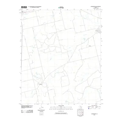
2010 Map of Longworth
USGS Topo · Published 2010About this map
Longworth sits at a junction of local roads in this West Texas survey, serving as a focal point for the surrounding agricultural lands of Fisher County. To the northeast, the settlement of Sylvester is clearly defined, with the nearby Sylvester Cemetery providing a localized record of the area's residents. The landscape is characterized by an intricate drainage system, with the Clear Fork winding through the northern portion of the quadrangle. Other prominent waterways including Cottonwood Creek, Sandy Creek, and Plum Creek cut across the territory, illustrating the natural watershed that has historically dictated the placement of homesteads and grazing lands. A network of county roads, such as Co RD 106 and Co RD 108, connects these small communities, while FM 1085 and FM 57 provide more modern thoroughfares through the rural terrain. The southeastern corner is notably defined by the path of China Creek and its tributary, East China Creek, further detailing the hydrology of this semi-arid region.
Find a feature on this map
30 named features on this map. Tap any name to fly to it.
Don’t see what you’re looking for? This feature index may not catch every label — zoom into the map to look around manually.
Map Details
Editions of this 2010 Longworth Map
This is the sole edition of this map. No revisions or reprints were ever made.
Other maps of this area

1893 · Roby
USGS Topo · 1:125,000

1931 · Rotan
USGS Topo · 1:62,500

1954 · Big Spring
USGS Topo · 1:250,000

1957 · Noodle
USGS Topo · 1:62,500

1958 · Big Spring
USGS Topo · 1:250,000

1965 · McCaulley
USGS Topo · 1:24,000

1969 · Rotan
USGS Topo · 1:24,000

1969 · Busby
USGS Topo · 1:24,000
1969 · Roby
USGS Topo · 1:24,000

1969 · Eskota
USGS Topo · 1:24,000