
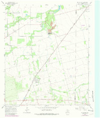
1965 Map of McCaulley
USGS Topo · Published 1967About this map
McCaulley serves as the primary hub of this West Texas landscape, positioned at a significant junction of the Atchison Topeka And Santa Fe railroad. The map illustrates a mid-century economy built on a combination of industrial extraction and agriculture, with a notable Strip Mine and the Celotex plant site located just north of the town center. To the west, the community of Reynolds and the Swedonia Cem provide important reference points for genealogists tracing family roots in the area. The hydrology of the region is defined by the winding paths of California Creek and Dry California Creek, which feed into local reservoirs like Plasterco Lake and West Lake. These water features, alongside scattered Oil Well sites and a local Golf Course near Hamlin, reveal the diverse land use patterns characterizing the transition from rangeland to industrial utility during the 1960s.
Find a feature on this map
26 named features on this map. Tap any name to fly to it.
Don’t see what you’re looking for? This feature index may not catch every label — zoom into the map to look around manually.
Map Details
Editions of this 1965 McCaulley Map
2 editions found
Other maps of this area

1893 · Roby
USGS Topo · 1:125,000

1931 · Rotan
USGS Topo · 1:62,500

1954 · Big Spring
USGS Topo · 1:250,000

1957 · Noodle
USGS Topo · 1:62,500

1958 · Big Spring
USGS Topo · 1:250,000
1965 · Hamlin NE
USGS Topo · 1:24,000
1965 · Neinda
USGS Topo · 1:24,000
1965 · Hamlin NW
USGS Topo · 1:24,000
1969 · Poke Mountain
USGS Topo · 1:24,000
1969 · Longworth
USGS Topo · 1:24,000