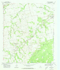
1969 Map of Longworth
USGS Topo · Published 1973About this map
The settlement of Longworth serves as a primary anchor in this Fisher County landscape, situated at the intersection of local roads and the Atchison Topeka and Santa Fe railroad line. To the northeast, the community of Sylvester is marked by its concentration of buildings and the nearby Sylvester Cem. The terrain is deeply etched by a network of waterways including Plum Creek, Sandy Creek, and Cottonwood Creek, all draining toward the Clear Fork Brazos River which meanders through the northern section of the quadrangle.
Find a feature on this map
13 named features on this map. Tap any name to fly to it.
Don’t see what you’re looking for? This feature index may not catch every label — zoom into the map to look around manually.
Map Details
Editions of this 1969 Longworth Map
This is the sole edition of this map. No revisions or reprints were ever made.
Other maps of this area

1893 · Roby
USGS Topo · 1:125,000

1931 · Rotan
USGS Topo · 1:62,500

1954 · Big Spring
USGS Topo · 1:250,000

1957 · Noodle
USGS Topo · 1:62,500

1958 · Big Spring
USGS Topo · 1:250,000

1965 · McCaulley
USGS Topo · 1:24,000

1969 · Rotan
USGS Topo · 1:24,000

1969 · Busby
USGS Topo · 1:24,000
1969 · Roby
USGS Topo · 1:24,000

1969 · Eskota
USGS Topo · 1:24,000