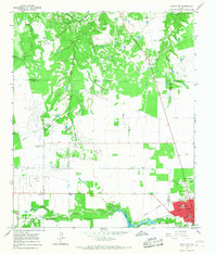
1965 Map of Hamlin NW
USGS Topo · Published 1967About this map
Hamlin serves as the focal point of this mid-1960s survey, showing a developed street grid that includes NW Second St and Fifth St, along with essential community landmarks like the Po, Jr High Sch, and High Sch. The landscape is defined by the intersection of energy production and agriculture, evidenced by numerous Oil Wells and a prominent Pipeline cutting across the county lines of Stonewall and Fisher Counties.
Find a feature on this map
42 named features on this map. Tap any name to fly to it.
Don’t see what you’re looking for? This feature index may not catch every label — zoom into the map to look around manually.
Map Details
Editions of this 1965 Hamlin NW Map
This is the sole edition of this map. No revisions or reprints were ever made.
Other maps of this area

1893 · Roby
USGS Topo · 1:125,000

1931 · Rotan
USGS Topo · 1:62,500

1931 · Aspermont
USGS Topo · 1:62,500

1954 · Lubbock
USGS Topo · 1:250,000

1954 · Big Spring
USGS Topo · 1:250,000

1958 · Big Spring
USGS Topo · 1:250,000
1962 · Frog Mountain
USGS Topo · 1:24,000
1965 · Hamlin NE
USGS Topo · 1:24,000
1965 · Neinda
USGS Topo · 1:24,000

1965 · McCaulley
USGS Topo · 1:24,000