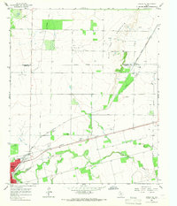
1965 Map of Hamlin NE
USGS Topo · Published 1967About this map
Hamlin serves as the primary hub in this mid-1960s landscape, positioned at the intersection of significant transportation and industrial corridors. The town is flanked by a Municipal Airport and Sewage Disposal facility, while the surrounding rural landscape is defined by the convergence of the Atchison Topeka and Santa Fe and Missouri Kansas Texas railroads. To the north, an expansive Oil Field stretches toward the Stonewall Co Jones Co line, indicating the region's reliance on mineral extraction.
Find a feature on this map
19 named features on this map. Tap any name to fly to it.
Don’t see what you’re looking for? This feature index may not catch every label — zoom into the map to look around manually.
Map Details
Editions of this 1965 Hamlin NE Map
This is the sole edition of this map. No revisions or reprints were ever made.
Other maps of this area

1891 · Anson
USGS Topo · 1:125,000

1893 · Roby
USGS Topo · 1:125,000

1893 · Anson
USGS Topo · 1:125,000

1931 · Aspermont
USGS Topo · 1:62,500

1954 · Lubbock
USGS Topo · 1:250,000

1954 · Big Spring
USGS Topo · 1:250,000

1954 · Abilene
USGS Topo · 1:250,000

1954 · Wichita Falls
USGS Topo · 1:250,000

1958 · Big Spring
USGS Topo · 1:250,000

1958 · Wichita Falls
USGS Topo · 1:250,000