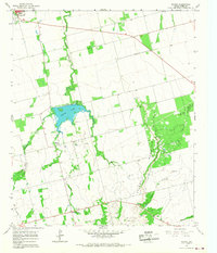
1965 Map of Neinda
USGS Topo · Published 1967About this map
The settlement of Neinda sits at the heart of this Jones County landscape, characterized by the winding path of Dry California Creek and the man-made expanse of South Lake. In the mid-1960s, the area's economy is clearly defined by natural resource extraction, with numerous Oil Wells and Gravel Pits dotting the terrain. The presence of Mountain and its associated Skinout Creek drainage provide significant topographic relief to the east of the primary settlements.
Find a feature on this map
20 named features on this map. Tap any name to fly to it.
Don’t see what you’re looking for? This feature index may not catch every label — zoom into the map to look around manually.
Map Details
Editions of this 1965 Neinda Map
This is the sole edition of this map. No revisions or reprints were ever made.
Other maps of this area

1891 · Anson
USGS Topo · 1:125,000

1893 · Roby
USGS Topo · 1:125,000

1893 · Anson
USGS Topo · 1:125,000

1954 · Big Spring
USGS Topo · 1:250,000

1954 · Abilene
USGS Topo · 1:250,000

1957 · Hawley
USGS Topo · 1:62,500

1957 · Noodle
USGS Topo · 1:62,500

1958 · Big Spring
USGS Topo · 1:250,000

1958 · Abilene
USGS Topo · 1:250,000

1965 · Tuxedo
USGS Topo · 1:24,000