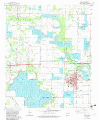
1982 Map of Lonoke
USGS Topo · Published 1982About this map
The Hogan State Fish Hatchery and numerous private ponds dominate the landscape of the Grand Prairie in this early 1980s look at central Arkansas. The county seat of Lonoke is depicted in detail, showing civic landmarks like the Courthouse, City Hall, and High Sch. The surrounding rural character is defined by a heavy investment in aquaculture and water management, with extensive gridded ponds and drainage patterns following Bayou Two Prairie and Bayou Meto. Local history is preserved in sites like the Brownsville Ch and several family or community burial grounds including Burris Cem, Beard Cem, and Hester Cem. Small settlements like Furlow and Brownsville sit amidst a network of farm roads and natural waterways like White Oak Branch, reflecting the region's agricultural transition from traditional field crops to specialized fish farming.
Find a feature on this map
29 named features on this map. Tap any name to fly to it.
Don’t see what you’re looking for? This feature index may not catch every label — zoom into the map to look around manually.
Map Details
Editions of this 1982 Lonoke Map
This is the sole edition of this map. No revisions or reprints were ever made.
Other maps of this area

1891 · Little Rock
USGS Topo · 1:125,000

1893 · Little Rock
USGS Topo · 1:125,000

1937 · England
USGS Topo · 1:48,000

1940 · Lonoke
USGS Topo · 1:62,500

1941 · Cabot
USGS Topo · 1:31,680

1942 · Scott
USGS Topo · 1:31,680

1943 · England
USGS Topo · 1:62,500

1943 · Jacksonville
USGS Topo · 1:31,680

1948 · Helena
USGS Topo · 1:250,000

1949 · Lonoke
USGS Topo · 1:62,500