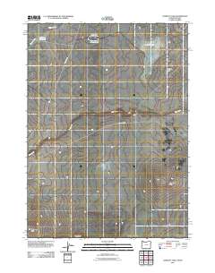
2011 Map of Lookout Lake
USGS Topo · Published 2011About this map
Lookout Lake and the high desert terrain of Malheur County define this 2011 survey, which straddles the Oregon-Nevada border. This arid landscape is punctuated by essential water management features such as the Airplane Reservoir and Black Butte Lake Reservoir, indicating the importance of water storage in this cattle-ranching and range country. Drainage patterns are established by Toppin Creek and Tent Creek, while prominent geological rises like McGinnis Ridge, Willow Creek Butte, and Mahogany Butte provide distinct navigational landmarks across the basin. The infrastructure of the area is sparse, primarily centered on Tent Creek Rd, which serves as the primary artery through this high plateau environment. This map offers a clear view of the geographic isolation and topography of the Great Basin's northern reaches at the beginning of the twenty-first century.
Find a feature on this map
9 named features on this map. Tap any name to fly to it.
Don’t see what you’re looking for? This feature index may not catch every label — zoom into the map to look around manually.
Map Details
Editions of this 2011 Lookout Lake Map
This is the sole edition of this map. No revisions or reprints were ever made.
Other maps of this area

1882 · Paradise
USGS Topo · 1:250,000

1893 · Paradise
USGS Topo · 1:250,000

1955 · McDermitt
USGS Topo · 1:250,000

1955 · Jordan Valley
USGS Topo · 1:250,000

1957 · Jordan Valley
USGS Topo · 1:250,000

1958 · Jordan Valley
USGS Topo · 1:250,000

1959 · McDermitt
USGS Topo · 1:250,000

1980 · Calico Butte
USGS Topo · 1:24,000

1980 · Mahogany Spring
USGS Topo · 1:24,000
1980 · Nadine Butte
USGS Topo · 1:24,000