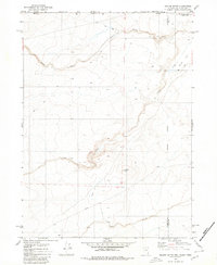
1980 Map of Nadine Butte
USGS Topo · Published 1980About this map
Nadine Butte rises as a central landmark in this high-desert region where the borders of Nevada, Idaho, and Oregon meet. Mapped from aerial photography taken in the mid-1970s, the landscape is defined by the intersection of remote county boundaries, including the Malheur Co Humboldt Co line and an Indefinite Boundary further east. The terrain is characterized by broad alluvial features like Alkali Flat and Cathcart Flat, which are carved by seasonal watercourses such as Willow Creek and Calico Creek. A network of Jeep Trails provides the primary access through the steep topography, pointing to the region's historical reliance on rugged overland routes. Notable human infrastructure is sparse but specific, including a marked Aqueduct and a Cave located near the southern drainage of Raven Creek.
Find a feature on this map
16 named features on this map. Tap any name to fly to it.
Don’t see what you’re looking for? This feature index may not catch every label — zoom into the map to look around manually.
Map Details
Editions of this 1980 Nadine Butte Map
This is the sole edition of this map. No revisions or reprints were ever made.
Other maps of this area

1882 · Paradise
USGS Topo · 1:250,000

1893 · Paradise
USGS Topo · 1:250,000

1955 · McDermitt
USGS Topo · 1:250,000

1955 · Jordan Valley
USGS Topo · 1:250,000

1957 · Jordan Valley
USGS Topo · 1:250,000

1958 · Jordan Valley
USGS Topo · 1:250,000

1959 · McDermitt
USGS Topo · 1:250,000

1973 · Star Valley Ridge SW
USGS Topo · 1:24,000
1973 · Star Valley
USGS Topo · 1:24,000
1973 · Star Valley Ridge West
USGS Topo · 1:24,000