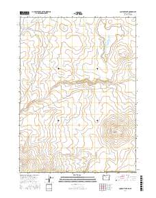
2017 Map of Lookout Lake
USGS Topo · Published 2017About this map
Lookout Lake and the high desert terrain of southeastern Oregon define this 2017 survey in Malheur County. The landscape is characterized by intermittent drainages and isolated water sources, including Airplane Reservoir and Black Butte Lake Reservoir, which serve as vital landmarks in this arid region. Significant topographic features like Willow Creek Butte and Mahogany Butte rise above the surrounding plateaus, providing distinct navigational points for those traversing the cattle country and range lands. The drainage patterns of Toppin Cr and Tent Cr illustrate the watershed's reliance on seasonal runoff. Access to this remote corner of the state is primarily provided by unpaved tracks such as Airplane Reservoir Rd and Tent Creek Rd, reflecting the enduring isolation of the Oregon high desert at the start of the 21st century.
Find a feature on this map
15 named features on this map. Tap any name to fly to it.
Don’t see what you’re looking for? This feature index may not catch every label — zoom into the map to look around manually.
Map Details
Editions of this 2017 Lookout Lake Map
This is the sole edition of this map. No revisions or reprints were ever made.
Other maps of this area

1882 · Paradise
USGS Topo · 1:250,000

1893 · Paradise
USGS Topo · 1:250,000

1955 · McDermitt
USGS Topo · 1:250,000

1955 · Jordan Valley
USGS Topo · 1:250,000

1957 · Jordan Valley
USGS Topo · 1:250,000

1958 · Jordan Valley
USGS Topo · 1:250,000

1959 · McDermitt
USGS Topo · 1:250,000

1980 · Calico Butte
USGS Topo · 1:24,000

1980 · Mahogany Spring
USGS Topo · 1:24,000
1980 · Nadine Butte
USGS Topo · 1:24,000