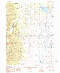
1990 Map of Lookout
USGS Topo · Published 1990About this map
The Big Valley basin forms a distinctive hydrologic landscape where the Modoc and Lassen county line meets the southern edge of the Modoc National Forest. This 1990 provisional map documents a complex network of water management features, including Fulcher Dam, Gerig Dam, and several reservoirs such as Lower Roberts Reservoir and Taylor Reservoir. The presence of numerous Check Dams and sloughs like Bull Run Slough and Egg Lake Slough indicates a managed riparian environment focused on the Ash Creek drainage. Settled areas are concentrated near the community of Lookout and the rail-oriented Lookout Siding in the north, while the southern reaches transition into the Ash Creek State Wildlife Area. This map is particularly valuable for tracing the hydraulic history of the region, showing how Ash Creek and the Pit River (recorded here as the Pit River) intersect with agricultural and conservation landmarks.
Find a feature on this map
48 named features on this map. Tap any name to fly to it.
Don’t see what you’re looking for? This feature index may not catch every label — zoom into the map to look around manually.
Map Details
Editions of this 1990 Lookout Map
This is the sole edition of this map. No revisions or reprints were ever made.
Other maps of this area

1886 · Modoc Lava Bed
USGS Topo · 1:250,000

1892 · Modoc Lava-Bed
USGS Topo · 1:250,000

1954 · Alturas
USGS Topo · 1:250,000

1958 · Alturas
USGS Topo · 1:250,000

1961 · Bieber
USGS Topo · 1:62,500

1961 · Fall River Mills
USGS Topo · 1:62,500

1962 · Alturas
USGS Topo · 1:250,000

1962 · Crank Mountain
USGS Topo · 1:62,500

1962 · White Horse
USGS Topo · 1:62,500

1965 · Alturas
USGS Topo · 1:250,000