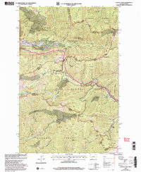
1999 Map of Lookout Pass
USGS Topo · Published 2003About this map
Lookout Pass sits at the high-altitude junction of the Idaho and Montana border, serving as a critical corridor through the Bitterroot Range. This 1999 revision highlights a landscape defined by the intersection of recreation, industrial history, and major transportation routes. The Lookout Pass Ski Area straddles the state line, while the peaks of Snowstorm Peak and Runt Mountain overlook a complex network of mining claims. A dense concentration of legacy workings, including the Snowstorm Mine, Lucky Calumet Mine, and Beacon Light Mines, follows the drainage of the South Fork Coeur d'Alene River toward the town of Mullan.
Find a feature on this map
54 named features on this map. Tap any name to fly to it.
Don’t see what you’re looking for? This feature index may not catch every label — zoom into the map to look around manually.
Map Details
Editions of this 1999 Lookout Pass Map
This is the sole edition of this map. No revisions or reprints were ever made.
Other maps of this area

1901 · Coeur D'Alene District
USGS Topo · 1:62,500

1903 · Coeur D'Alene District
USGS Topo · 1:62,500

1906 · Coeur D'Alene District
USGS Topo · 1:62,500

1914 · Avery
USGS Topo · 1:125,000

1917 · Avery
USGS Topo · 1:125,000

1932 · Trout Creek
USGS Topo · 1:125,000

1935 · Trout Creek
USGS Topo · 1:125,000

1936 · Trout Creek
USGS Topo · 1:125,000

1956 · Cooper Gulch
USGS Topo · 1:62,500

1956 · Saltese
USGS Topo · 1:62,500