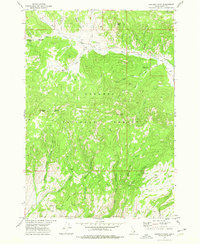
1972 Map of Lookout Point
USGS Topo · Published 1976About this map
Targhee National Forest dominates this section of Clark County, defined by a complex network of high peaks and drainage basins documented in the early 1970s. The landscape is structured by deep canyons and prominent summits including Signal Peak, Castle Peak, and the namesake Lookout Point. Natural movement through the high country is indicated by several established routes such as the Pass Creek Trail and Lone Pine Pass.
Find a feature on this map
39 named features on this map. Tap any name to fly to it.
Don’t see what you’re looking for? This feature index may not catch every label — zoom into the map to look around manually.
Map Details
Editions of this 1972 Lookout Point Map
This is the sole edition of this map. No revisions or reprints were ever made.
Other maps of this area

1950 · Lower Red Rock Lake
USGS Topo · 1:62,500

1955 · Dubois
USGS Topo · 1:250,000

1955 · Ashton
USGS Topo · 1:250,000

1958 · Dubois
USGS Topo · 1:250,000

1958 · Ashton
USGS Topo · 1:250,000

1960 · Ashton
USGS Topo · 1:250,000

1968 · Corral Creek
USGS Topo · 1:24,000

1968 · Big Table Mountain
USGS Topo · 1:24,000

1972 · Spencer South
USGS Topo · 1:24,000

1972 · Kilgore
USGS Topo · 1:24,000