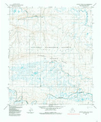
1984 Map of Lookout Ridge A-5
USGS Topo · Published 1985About this map
The Colville River carves through the southern portion of this Arctic landscape, joined by its tributaries the Nuka River and Grayling Creek. This mid-1980s survey captures a vast section of the National Petroleum Reserve In Alaska, a region defined by its complex drainage patterns and the prominent geological formation of Lookout Ridge. In the northern half of the quadrangle, Carbon Creek and the Awuna River flow through a terrain marked by numerous small ponds and wetland areas, typical of the North Slope's permafrost-influenced geography. Named topographic points like Gradin and Out serve as critical reference markers in an area largely devoid of permanent settlements or infrastructure, illustrating the Bureau of Land Management's pre-surveyed grid system used for resource management in the late twentieth century.
Find a feature on this map
12 named features on this map. Tap any name to fly to it.
Don’t see what you’re looking for? This feature index may not catch every label — zoom into the map to look around manually.
Map Details
Editions of this 1984 Lookout Ridge A-5 Map
This is the sole edition of this map. No revisions or reprints were ever made.
Other maps of this area

1951 · Utukok River
USGS Topo · 1:250,000

1951 · Lookout Ridge
USGS Topo · 1:250,000

1951 · Howard Pass
USGS Topo · 1:250,000

1951 · Misheguk Mountain
USGS Topo · 1:250,000

1956 · Lookout Ridge
USGS Topo · 1:250,000

1956 · Howard Pass
USGS Topo · 1:250,000

1956 · Misheguk Mountain
USGS Topo · 1:250,000

1956 · Utukok River
USGS Topo · 1:250,000

1965 · Utukok River
USGS Topo · 1:250,000
1984 · Howard Pass D-4
USGS Topo · 1:63,360