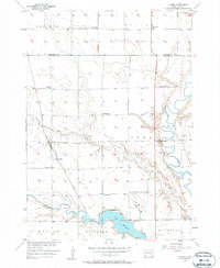
1957 Map of Loomis
USGS Topo · Published 1958About this map
Loomis sits at the center of this 1957 survey, a small settlement defined by the north-south tracks of the Chicago Milwaukee St Paul and Pacific railroad. The surrounding prairie landscape is organized into civil townships including Badger, Perry, and Letcher, where a network of rural schoolhouses such as Titus Sch, Jefferson Sch, and Lincoln Sch served the farming community. The topography is marked by the winding course of the James River to the east and the significant presence of Lake Mitchell at the southern boundary.
Find a feature on this map
27 named features on this map. Tap any name to fly to it.
Don’t see what you’re looking for? This feature index may not catch every label — zoom into the map to look around manually.
Map Details
Editions of this 1957 Loomis Map
2 editions found
Other maps of this area

1899 · Mitchell
USGS Topo · 1:125,000

1899 · Alexandria
USGS Topo · 1:125,000

1955 · Sioux Falls
USGS Topo · 1:250,000

1955 · Mitchell
USGS Topo · 1:250,000

1957 · Farwell NW
USGS Topo · 1:24,000

1957 · Loomis
USGS Topo · 1:24,000

1957 · Riverside
USGS Topo · 1:24,000

1957 · Letcher NE
USGS Topo · 1:24,000

1957 · Farwell
USGS Topo · 1:24,000

1957 · Mitchell
USGS Topo · 1:24,000