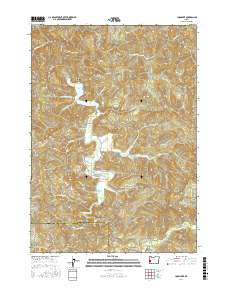
2017 Map of Loon Lake
USGS Topo · Published 2017About this map
Loon Lake and the surrounding drainage basins of the Douglas Co / Coos Co border define this landscape in the Oregon Coast Range. The settlement at Ash Valley and the smaller locality of Ash are central points of human activity, situated among the complex network of creeks that feed the lake, including Little Salander Cr and Lake Creek. Notable geological landmarks like Beehive Rock and Saint Patricks Rock rise above the water, while Umpcoos Ridge and Michigan Pass provide prominent topographic markers for navigating the timbered slopes. This survey captures a modern look at the remote logging and access roads, such as Elk Ridge Forest Rd and Loon Lake Rd, that have replaced earlier pioneer trails. The presence of Platinum Falls further south emphasizes the steep, water-carved character of the terrain.
Find a feature on this map
45 named features on this map. Tap any name to fly to it.
Don’t see what you’re looking for? This feature index may not catch every label — zoom into the map to look around manually.
Map Details
Editions of this 2017 Loon Lake Map
This is the sole edition of this map. No revisions or reprints were ever made.
Other maps of this area

1928 · Sitkum
USGS Topo · 1:125,000

1955 · Scottsburg
USGS Topo · 1:62,500

1955 · Ivers Peak
USGS Topo · 1:62,500

1955 · Tyee
USGS Topo · 1:62,500

1955 · Elkton
USGS Topo · 1:62,500

1958 · Roseburg
USGS Topo · 1:250,000

1959 · Roseburg
USGS Topo · 1:250,000

1979 · Roseburg
USGS Topo · 1:100,000

1979 · Cottage Grove
USGS Topo · 1:100,000
1985 · Loon Lake
USGS Topo · 1:24,000