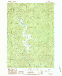
1985 Map of Loon Lake
USGS Topo · Published 1985About this map
Loon Lake and the surrounding Elliott State Forest define this landscape in the mid-1980s. The map captures the small settlement of Ash within Ash Valley, where Lake Creek flows through the central terrain. This area is a hub for recreation, featuring the East Shore Recreation Site, various Campgrounds, a Boat Ramp, and Picnic Areas along the water's edge. Notable natural landmarks like Beehive Rock and St Patricks Rock stand near the shoreline, while the higher elevations are marked by Michigan Pass and several lookouts, including a Lookout Tower and Radio tower. A network of water bodies, such as Soup Creek, Buck Creek, and Mill Creek, drains the timbered slopes. Evidence of local industry appears in the form of a Quarry near Craig Creek and the Fence Line trail, providing a detailed view of the infrastructure supporting both forestry and outdoor activities in Douglas County.
Find a feature on this map
42 named features on this map. Tap any name to fly to it.
Don’t see what you’re looking for? This feature index may not catch every label — zoom into the map to look around manually.
Map Details
Editions of this 1985 Loon Lake Map
This is the sole edition of this map. No revisions or reprints were ever made.
Other maps of this area

1928 · Sitkum
USGS Topo · 1:125,000

1955 · Scottsburg
USGS Topo · 1:62,500

1955 · Ivers Peak
USGS Topo · 1:62,500

1955 · Tyee
USGS Topo · 1:62,500

1955 · Elkton
USGS Topo · 1:62,500

1958 · Roseburg
USGS Topo · 1:250,000

1959 · Roseburg
USGS Topo · 1:250,000

1979 · Roseburg
USGS Topo · 1:100,000

1979 · Cottage Grove
USGS Topo · 1:100,000
1985 · Elk Peak
USGS Topo · 1:24,000