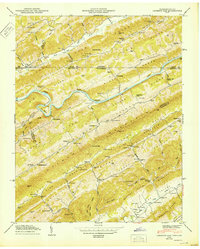
1950 Map of Looneys Gap
USGS Topo · Published 1950About this map
The Clinch River carves a dramatic oxbow known as The Rounds as it winds through this corner of East Tennessee and Southwest Virginia in the late 1940s. The landscape is defined by the sharp, parallel ridges of Clinch Mountain and Copper Ridge, which confine settlement to the narrow corridors of Clinch Valley and Poor Valley. This rural topography supported a network of small community hubs, including Big Springs and Snow Flake, alongside numerous family-named landmarks like Rogers Cem and Garter Cem.
Find a feature on this map
118 named features on this map. Tap any name to fly to it.
Don’t see what you’re looking for? This feature index may not catch every label — zoom into the map to look around manually.
Map Details
Editions of this 1950 Looneys Gap Map
This is the sole edition of this map. No revisions or reprints were ever made.
Other maps of this area

1883 · Morristown
USGS Topo · 1:125,000

1887 · Jonesville
USGS Topo · 1:125,000

1891 · Jonesville
USGS Topo · 1:125,000

1892 · Greeneville
USGS Topo · 1:125,000

1893 · Morristown
USGS Topo · 1:125,000

1894 · Estillville
USGS Topo · 1:125,000

1895 · Morristown
USGS Topo · 1:125,000

1896 · Greeneville
USGS Topo · 1:125,000

1904 · Greeneville
USGS Topo · 1:125,000

1935 · Surgoinsville
USGS Topo · 1:48,000