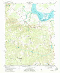
1968 Map of Loretto
USGS Topo · Published 1972About this map
The Rappahannock River defines the northern edge of this coastal plain landscape, where the tides met the commerce of the 1960s at Saunders Wharf. The map details a deeply rooted rural community across the Caroline and Essex County lines, anchored by historic congregations at Vauters Ch, Mt Salem Ch, and Bethlehem Ch. The terrain transitions from the marshy lowlands of Drakes Marsh and Otterburn Marsh into the dissected uplands of the interior. The settlement pattern follows the ridges between drainages like Occupacia Creek and Elmwood Creek, connecting small crossroads such as Hustle, Iraville, and Lloyds. Of particular interest to genealogists are the numerous small cemeteries and the site of Hunters Millpond, which points to earlier water-powered industry in the region.
Find a feature on this map
39 named features on this map. Tap any name to fly to it.
Don’t see what you’re looking for? This feature index may not catch every label — zoom into the map to look around manually.
Map Details
Editions of this 1968 Loretto Map
4 editions found
Other maps of this area

1889 · Fredericksburg
USGS Topo · 1:125,000

1892 · Fredericksburg
USGS Topo · 1:125,000

1892 · Montross
USGS Topo · 1:62,500

1894 · Fredericksburg
USGS Topo · 1:125,000

1895 · Nomini
USGS Topo · 1:125,000

1895 · Montross
USGS Topo · 1:62,500

1898 · Nomini
USGS Topo · 1:125,000

1918 · Tappahannock
USGS Topo · 1:62,500

1918 · Aylett
USGS Topo · 1:62,500

1919 · Tappahannock
USGS Topo · 1:62,500