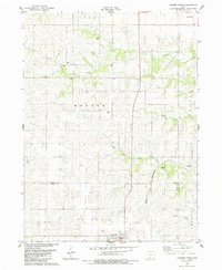
1983 Map of Lorimor North
USGS Topo · Published 1984About this map
Lorimor serves as the primary focal point in the southern portion of this Iowa landscape, where the Chicago and North Western rail line cuts through the rolling terrain. The map captures a rural network of small agricultural townships including Monroe and New Hope, linked by gravel roads and family landmarks. This 1980s topography reflects a mature farming landscape where local heritage is preserved in numerous rural burial grounds like Clark Cem and Hamblin Cem.
Find a feature on this map
26 named features on this map. Tap any name to fly to it.
Don’t see what you’re looking for? This feature index may not catch every label — zoom into the map to look around manually.
Map Details
Editions of this 1983 Lorimor North Map
This is the sole edition of this map. No revisions or reprints were ever made.
Other maps of this area

1951 · Osceola
USGS Topo · 1:62,500

1951 · St. Charles
USGS Topo · 1:62,500

1951 · Afton
USGS Topo · 1:62,500

1952 · Winterset
USGS Topo · 1:62,500

1954 · Omaha
USGS Topo · 1:250,000

1954 · Des Moines
USGS Topo · 1:250,000

1956 · Des Moines
USGS Topo · 1:250,000

1957 · Des Moines
USGS Topo · 1:250,000

1957 · Omaha
USGS Topo · 1:250,000

1958 · Omaha
USGS Topo · 1:250,000