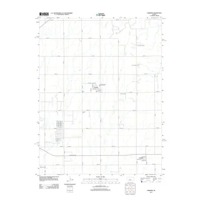
2012 Map of Lorraine
USGS Topo · Published 2012About this map
Lorraine and Frederick center this survey of the central Kansas prairie, where a grid of rural roads like Avenue R and 10th Rd structures the agricultural landscape. The region's subsurface wealth is clearly documented by numerous active petroleum sites, including the Green Garden Oil Field and the Prosper East Oil Field, which punctuate the sections between traditional farmsteads.
Find a feature on this map
42 named features on this map. Tap any name to fly to it.
Don’t see what you’re looking for? This feature index may not catch every label — zoom into the map to look around manually.
Map Details
Editions of this 2012 Lorraine Map
This is the sole edition of this map. No revisions or reprints were ever made.
Other maps of this area

1894 · Ellsworth
USGS Topo · 1:125,000

1894 · Lyons
USGS Topo · 1:125,000

1955 · Great Bend
USGS Topo · 1:250,000

1957 · Great Bend
USGS Topo · 1:250,000

1957 · Ellsworth
USGS Topo · 1:24,000

1957 · Holyrood NE
USGS Topo · 1:24,000

1958 · Great Bend
USGS Topo · 1:250,000
1964 · Holyrood NW
USGS Topo · 1:24,000
1964 · Holyrood
USGS Topo · 1:24,000
1964 · Geneseo
USGS Topo · 1:24,000