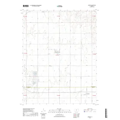
2018 Map of Lorraine
USGS Topo · Published 2018About this map
Lorraine sits at the heart of this Central Kansas landscape, serving as a hub for the surrounding agricultural sections in western Ellsworth County. The area is defined by its drainage systems, with Turkey Cr and Oxide Cr flowing south toward the border between Ellsworth and Rice Counties. Significant for family historians and genealogists, the map identifies several distinct burial sites including the Henry Family Cem in the north and both the Baptist Cem and Lorraine Cem closer to the town center. The township and range lines, such as t17s r9w, reveal the structured grid of the Public Land Survey System that governs the placement of local thoroughfares like Wichita Ave and 2nd Ave. To the southwest, Plum Cr meanders near a series of large industrial or agricultural basins, illustrating the local land use and resource management of the late 2010s.
Find a feature on this map
32 named features on this map. Tap any name to fly to it.
Don’t see what you’re looking for? This feature index may not catch every label — zoom into the map to look around manually.
Map Details
Editions of this 2018 Lorraine Map
This is the sole edition of this map. No revisions or reprints were ever made.
Other maps of this area

1894 · Ellsworth
USGS Topo · 1:125,000

1894 · Lyons
USGS Topo · 1:125,000

1955 · Great Bend
USGS Topo · 1:250,000

1957 · Great Bend
USGS Topo · 1:250,000

1957 · Ellsworth
USGS Topo · 1:24,000

1957 · Holyrood NE
USGS Topo · 1:24,000

1958 · Great Bend
USGS Topo · 1:250,000
1964 · Holyrood NW
USGS Topo · 1:24,000
1964 · Holyrood
USGS Topo · 1:24,000
1964 · Geneseo
USGS Topo · 1:24,000