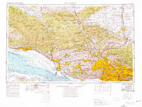
1953 Map of Los Angeles
USGS Topo · Published 1956About this map
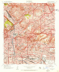
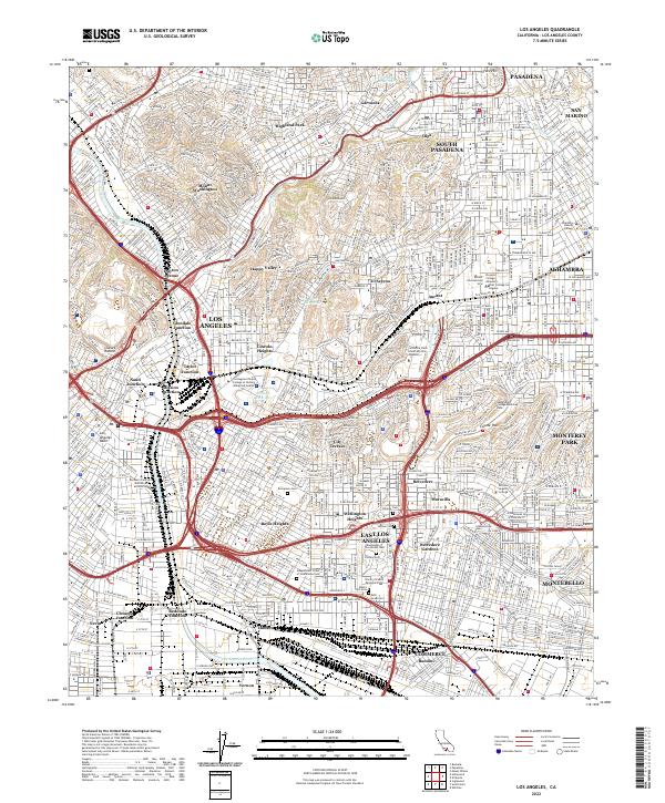
Evergreen Cem and Home of Peace Cem anchor the landscape of East Los Angeles in this mid-century view, showing the dense clustering of community institutions and industrial corridors. The Los Angeles River serves as a primary geographic divider, flanked by the massive rail infrastructure of the Union Pacific and Southern Pacific railroads. Centered around City Hall and Union Station, the downtown core transitions into established neighborhoods like Boyle Heights and Lincoln Heights, which are shown just as the modern freeway system began to reshape the urban fabric.
Find a feature on this map
79 named features on this map. Tap any name to fly to it.
Don’t see what you’re looking for? This feature index may not catch every label — zoom into the map to look around manually.
Map Details
Editions of this 1953 Los Angeles Map
This is the sole edition of this map. No revisions or reprints were ever made.
Historical Maps of Los Angeles Through Time
13 maps found
1928 Los Angeles
Los Angeles County, CA

1949 Los Angeles
Los Angeles County, CA
1953 Los Angeles
Los Angeles County, CA

1955 Los Angeles
Los Angeles County, CA
1959 Los Angeles
Los Angeles County, CA

1966 Los Angeles
Los Angeles County, CA
1966 Los Angeles
Los Angeles County, CA
1975 Los Angeles
Los Angeles County, CA

1979 Los Angeles
Los Angeles County, CA
2012 Los Angeles
Los Angeles County, CA
2015 Los Angeles
Los Angeles County, CA
2018 Los Angeles
Los Angeles County, CA
2022 Los Angeles
Los Angeles County, CA