
2019 Map of Los Ebanos NW
USGS Topo · Published 2019About this map
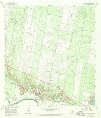
The Rio Grande snakes through the northern reach of this South Texas landscape, defining the international boundary between the United States of America and Estados Unidos Mexicanos. This 2019 survey captures the borderlands within Starr Co, Texas, where the river serves as the primary geographical feature amidst a vast expanse of brush and open terrain. The map documents the intricate bends and sandbars of the river as it appeared in the late 2010s, illustrating the natural division between two nations. Beyond the river corridor, the landscape is characterized by its drainage patterns and subtle elevation changes, providing a clear record of the physical border as it transitioned into the modern era.
Find a feature on this map
5 named features on this map. Tap any name to fly to it.
Don’t see what you’re looking for? This feature index may not catch every label — zoom into the map to look around manually.
Map Details
Editions of this 2019 Los Ebanos NW Map
This is the sole edition of this map. No revisions or reprints were ever made.
Other maps of this area

1949 · Mc Allen
USGS Topo · 1:250,000

1954 · McAllen
USGS Topo · 1:250,000

1956 · Garcias
USGS Topo · 1:62,500

1956 · Los Ebanos
USGS Topo · 1:62,500

1956 · Escobares
USGS Topo · 1:62,500

1957 · Mc Allen
USGS Topo · 1:250,000

1962 · McAllen
USGS Topo · 1:250,000

1965 · Rio Grande City South
USGS Topo · 1:24,000

1965 · La Grulla
USGS Topo · 1:24,000
1965 · Sullivan City
USGS Topo · 1:24,000