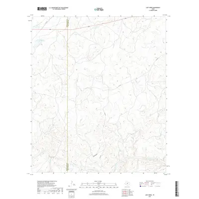
2019 Map of Lost Creek
USGS Topo · Published 2019About this map
McCulloch and San Saba Counties meet in this landscape defined by a network of seasonal watercourses and varying elevations. The drainage patterns of the Edwards Plateau are clearly visible as Lost Creek and Honey Creek carve through the center of the terrain, eventually feeding into larger systems like Brady Creek and Little Brady Creek in the south. The human footprint is marked primarily by ranch roads like County Road 426 and County Road 360, alongside water management infrastructure such as the Soil Conservation Service Site 1 Reservoir in the northwest. This topography, including the natural drainage at Plum Hollow, reflects a rural environment where land use is dictated by the limestone-influenced hydrology of the Texas Hill Country, captured here in the late twenty-teens.
Find a feature on this map
13 named features on this map. Tap any name to fly to it.
Don’t see what you’re looking for? This feature index may not catch every label — zoom into the map to look around manually.
Map Details
Editions of this 2019 Lost Creek Map
This is the sole edition of this map. No revisions or reprints were ever made.
Other maps of this area

1885 · San Saba
USGS Topo · 1:125,000

1894 · Brady
USGS Topo · 1:125,000

1894 · San Saba
USGS Topo · 1:125,000

1928 · Mercury
USGS Topo · 1:62,500

1930 · Richland Springs
USGS Topo · 1:62,500

1948 · Richland Springs
USGS Topo · 1:62,500

1950 · Mercury
USGS Topo · 1:62,500
1950 · Richland Springs
USGS Topo · 1:62,500

1954 · Brownwood
USGS Topo · 1:250,000
1955 · Brady Mountian
USGS Topo · 1:24,000