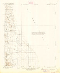
1914 Map of Lost Hills
USGS Topo · Published 1947About this map
The San Joaquin Valley is the primary setting for this early twentieth-century survey, revealing a landscape defined by sparse water sources and the rise of the Lost Hills and Kettleman Hills. Topography from a 1907-1908 survey shows the Antelope Plain before the massive expansion of the regional petroleum industry, focusing instead on early landmarks like the Dudley-Lemoore Road and isolated outposts such as McDonalds Ranch. The map highlights the critical importance of water in this arid stretch of Kings and Kern counties, marking the County Well, Alamo Solo Spr, and Bitterwater Creek. Tracing the edge of the Temblor Range, the survey documents natural features such as Avenal Gap and Pyramid Hills that would later become synonymous with the California oil boom.
Find a feature on this map
20 named features on this map. Tap any name to fly to it.
Don’t see what you’re looking for? This feature index may not catch every label — zoom into the map to look around manually.
Map Details
Editions of this 1914 Lost Hills Map
4 editions found
Other maps of this area

1910 · Buena Vista Lake
USGS Topo · 1:125,000

1912 · Coalinga
USGS Topo · 1:125,000

1912 · McKittrick
USGS Topo · 1:125,000

1912 · Buena Vista Lake
USGS Topo · 1:125,000

1914 · Lost Hills
USGS Topo · 1:125,000

1914 · Cholame
USGS Topo · 1:125,000

1915 · Cholame
USGS Topo · 1:125,000

1917 · Cholame
USGS Topo · 1:125,000

1927 · Semitropic
USGS Topo · 1:31,680

1927 · Lake View School
USGS Topo · 1:31,680