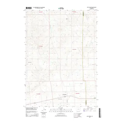
2015 Map of Lost Springs
USGS Topo · Published 2015About this map
Lost Springs serves as the primary focal point of this high-plains landscape, situated along the southern edge of a vast drainage network. The topography is defined by significant erosion features, including Watkins Draw and Stevenson Draw, which channel intermittent water toward a series of creeks. The eastern boundary is marked by the Converse Co Niobrara Co line, reflecting the administrative division of this ranching country. High points like Rocky Top provide vantage points over a terrain carved by the Lost Cr and Harney Cr systems. The road network, including Twenty Mile Creek Rd and Wright Rd, follows the natural contours of the land, connecting isolated ranching interests across the township and range sections of this eastern Wyoming territory.
Find a feature on this map
23 named features on this map. Tap any name to fly to it.
Don’t see what you’re looking for? This feature index may not catch every label — zoom into the map to look around manually.
Map Details
Editions of this 2015 Lost Springs Map
This is the sole edition of this map. No revisions or reprints were ever made.
Other maps of this area

1949 · Shawnee
USGS Topo · 1:24,000

1950 · Amend Ranch
USGS Topo · 1:24,000

1950 · Prairie View School
USGS Topo · 1:24,000

1950 · Shawnee
USGS Topo · 1:24,000

1954 · Torrington
USGS Topo · 1:250,000

1958 · Torrington
USGS Topo · 1:250,000
1961 · Shawnee
USGS Topo · 1:24,000

1970 · Lost Springs
USGS Topo · 1:24,000
1970 · The Park
USGS Topo · 1:24,000

1970 · Walker Creek School
USGS Topo · 1:24,000