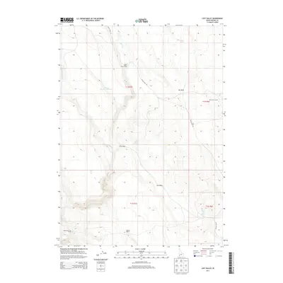
2013 Map of Lost Valley
USGS Topo · Published 2013About this map
Lost Valley and the high desert of Owyhee County are defined by a network of seasonal water sources and critical creek crossings essential for range navigation. This landscape, as mapped in 2013, centers on the drainage of Battle Cr, where historical access points like Upper Battle Creek Crossing and Lower Battle Creek Crossing mark the movement of people and livestock through the territory. The presence of Dry Creek Reservoir Number Six and multiple water points such as Wildhorse Spring and Lost Valley Springs illustrates the ongoing importance of water management in this arid region. From the elevation of Dollar Butte to the sheltered expanse of Bull Basin, the map traces the intersection of natural topography and the utilitarian infrastructure of Battle Creek Rd.
Find a feature on this map
19 named features on this map. Tap any name to fly to it.
Don’t see what you’re looking for? This feature index may not catch every label — zoom into the map to look around manually.
Map Details
Editions of this 2013 Lost Valley Map
This is the sole edition of this map. No revisions or reprints were ever made.
Other maps of this area

1955 · Jordan Valley
USGS Topo · 1:250,000

1957 · Jordan Valley
USGS Topo · 1:250,000

1958 · Jordan Valley
USGS Topo · 1:250,000
1972 · Frying Pan Basin
USGS Topo · 1:24,000
1972 · Big Springs Ranch
USGS Topo · 1:24,000
1972 · Crab Spring Butte
USGS Topo · 1:24,000

1972 · Turner Table
USGS Topo · 1:24,000
1972 · Nichol Flat
USGS Topo · 1:24,000
1972 · Shoofly Springs
USGS Topo · 1:24,000
1972 · Sugarloaf
USGS Topo · 1:24,000