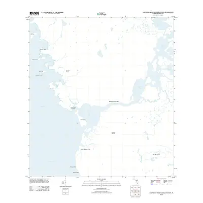
2012 Map of Lostmans River Ranger Station
USGS Topo · Published 2012About this map
Lostmans River winds through the labyrinthine coastal wetlands of Monroe County, serving as the central artery for this remote portion of the Gulf coast. In the early 21st century, this landscape remains defined by its isolated outposts and topographic anomalies, such as Hamilton Mound and Johnson Mound, which rise above the surrounding tidal flats. These sites, along with the Walter Hamilton Place and Leon Hamilton Place, reflect a history of human presence in a territory dominated by water and mangroves. The Lostmans River Ranger Station stands at the river's mouth, overlooking the transition into the Gulf of Mexico. The coastline is a complex network of points and keys, from Bird Key and Alligator Point in the north to the sandy stretch of Highland Beach at the southern edge of the survey.
Find a feature on this map
31 named features on this map. Tap any name to fly to it.
Don’t see what you’re looking for? This feature index may not catch every label — zoom into the map to look around manually.
Map Details
Editions of this 2012 Lostmans River Ranger Station Map
This is the sole edition of this map. No revisions or reprints were ever made.
Other maps of this area

1956 · Miami
USGS Topo · 1:250,000

1958 · Miami
USGS Topo · 1:250,000

1972 · Harney River
USGS Topo · 1:24,000

1972 · Big Boy Lake
USGS Topo · 1:24,000

1972 · Shark Point
USGS Topo · 1:24,000

1973 · Pavilion Key
USGS Topo · 1:24,000
1973 · Plover Key
USGS Topo · 1:24,000

1973 · Big Lostmans Bay
USGS Topo · 1:24,000

1973 · Lostmans River Ranger Station
USGS Topo · 1:24,000

1973 · Alligator Bay
USGS Topo · 1:24,000