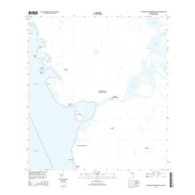
2015 Map of Lostmans River Ranger Station
USGS Topo · Published 2015About this map
Everglades National Park encompasses this intricate coastal landscape where the fresh waters of the interior meet the saltwater of the Gulf of Mexico. The map details the complex estuarine environment defined by the Lostmans River as it winds through First Bay and Second Bay. This specific shoreline is notable for its legacy of human occupancy in a challenging environment, marked by sites such as Walter Hamilton Place, Leon Hamilton Place, and Hamilton Mound. These locations, along with Johnson Mound, suggest a history of elevated sites being utilized for settlement or navigation amidst the mangroves and tidal flats. The Wilderness Waterway threads through the interior keys and bays, providing a navigational artery through Onion Key Bay and Two Island Bay. Protection and management of this wilderness are centered at the Lostmans River Ranger Station, located near Lostmans Key.
Find a feature on this map
33 named features on this map. Tap any name to fly to it.
Don’t see what you’re looking for? This feature index may not catch every label — zoom into the map to look around manually.
Map Details
Editions of this 2015 Lostmans River Ranger Station Map
This is the sole edition of this map. No revisions or reprints were ever made.
Other maps of this area

1956 · Miami
USGS Topo · 1:250,000

1958 · Miami
USGS Topo · 1:250,000

1972 · Harney River
USGS Topo · 1:24,000

1972 · Big Boy Lake
USGS Topo · 1:24,000

1972 · Shark Point
USGS Topo · 1:24,000

1973 · Pavilion Key
USGS Topo · 1:24,000
1973 · Plover Key
USGS Topo · 1:24,000

1973 · Big Lostmans Bay
USGS Topo · 1:24,000

1973 · Lostmans River Ranger Station
USGS Topo · 1:24,000

1973 · Alligator Bay
USGS Topo · 1:24,000