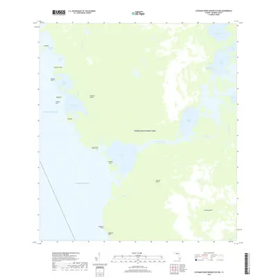
2018 Map of Lostmans River Ranger Station
USGS Topo · Published 2018About this map
Everglades National Park dominates this coastal landscape, where the labyrinthine waterways of the western Florida shelf meet the Gulf of Mexico. The map details a complex network of bays and mangrove keys, including First Bay, Second Bay, and Onion Key Bay, connected by the Wilderness Waterway. Inland sites such as Hamilton Mound and Johnson Mound suggest a long history of human presence in this amphibious environment, while the Lostmans River Ranger Station serves as a modern outpost for park management. The transition from open water to interior sawgrass and tidal creeks is visible through features like Lostmans River and Toms Creek, illustrating the delicate balance of the river-of-grass ecosystem. Coastal landmarks such as Highland Beach and Porpoise Point mark the outer edges of this protected wilderness.
Find a feature on this map
32 named features on this map. Tap any name to fly to it.
Don’t see what you’re looking for? This feature index may not catch every label — zoom into the map to look around manually.
Map Details
Editions of this 2018 Lostmans River Ranger Station Map
This is the sole edition of this map. No revisions or reprints were ever made.
Other maps of this area

1956 · Miami
USGS Topo · 1:250,000

1958 · Miami
USGS Topo · 1:250,000

1972 · Harney River
USGS Topo · 1:24,000

1972 · Big Boy Lake
USGS Topo · 1:24,000

1972 · Shark Point
USGS Topo · 1:24,000

1973 · Pavilion Key
USGS Topo · 1:24,000
1973 · Plover Key
USGS Topo · 1:24,000

1973 · Big Lostmans Bay
USGS Topo · 1:24,000

1973 · Lostmans River Ranger Station
USGS Topo · 1:24,000

1973 · Alligator Bay
USGS Topo · 1:24,000