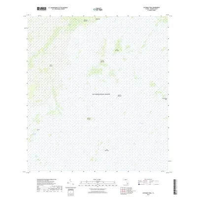
2018 Map of Lostmans Trail
USGS Topo · Published 2018About this map
Pinecrest sits at the northern edge of a landscape defined by the vast reach of Big Cypress National Preserve and the northern reaches of The Everglades. This 2018 survey illustrates the complex subtropical hydrology of Monroe County, where slow-moving water channels like Dayhoff Slough, Gum Slough, and Dixons Slough cut through the sawgrass. Higher ground is marked by numerous hammocks—distinctive islands of hardwood trees—including Dr Tiger Hammock, Fritz Hammock, and Tamarind Hammock. These features, along with landmarks like Sandy Mound, served as critical navigation points for travelers along the historic Lostmans Trail. The map provides a contemporary record of this wilderness, including Co RD 94 and the subtle rise of Rattlesnake Ridge on the eastern boundary.
Find a feature on this map
18 named features on this map. Tap any name to fly to it.
Don’t see what you’re looking for? This feature index may not catch every label — zoom into the map to look around manually.
Map Details
Editions of this 2018 Lostmans Trail Map
This is the sole edition of this map. No revisions or reprints were ever made.
Other maps of this area

1956 · Miami
USGS Topo · 1:250,000

1958 · Miami
USGS Topo · 1:250,000

1972 · Shark Valley Lookout Tower
USGS Topo · 1:24,000

1972 · Lostmans Trail
USGS Topo · 1:24,000

1972 · Big Boy Lake
USGS Topo · 1:24,000

1972 · Panther Mound
USGS Topo · 1:24,000

1972 · Indian Camp Creek
USGS Topo · 1:24,000

1973 · Fortymile Bend
USGS Topo · 1:24,000

1973 · Fiftymile Bend
USGS Topo · 1:24,000

1973 · Monroe Station
USGS Topo · 1:24,000