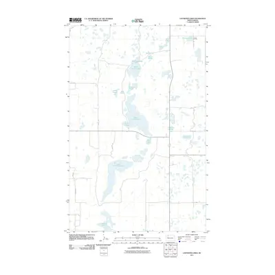
2011 Map of Lostwood Lakes
USGS Topo · Published 2011About this map
Vanville Cemetery sits in the northeast corner of this prairie pothole landscape, a primary marker for local family history in Burke County. The terrain is dominated by a dense network of glacial wetlands and water bodies, centered around the elongated basins of Upper Lostwood Lake and Lower Lostwood Lake. The complex hydrology of the region is evident in the variety of named sloughs and lakes, including Martinsen Lake, School Section Lake, and the descriptively named Dead Dog Slough.
Find a feature on this map
28 named features on this map. Tap any name to fly to it.
Don’t see what you’re looking for? This feature index may not catch every label — zoom into the map to look around manually.
Map Details
Editions of this 2011 Lostwood Lakes Map
This is the sole edition of this map. No revisions or reprints were ever made.
Other maps of this area

1948 · Vanville NE
USGS Topo · 1:24,000

1950 · Vanville NE
USGS Topo · 1:24,000

1953 · Williston
USGS Topo · 1:250,000

1957 · Williston
USGS Topo · 1:250,000
1974 · Thompson Lake
USGS Topo · 1:24,000
1974 · Helde Lake
USGS Topo · 1:24,000

1974 · Lostwood Lakes
USGS Topo · 1:24,000

1978 · Westby Lake
USGS Topo · 1:24,000
1978 · Lunds Valley
USGS Topo · 1:24,000

1981 · Lostwood
USGS Topo · 1:24,000