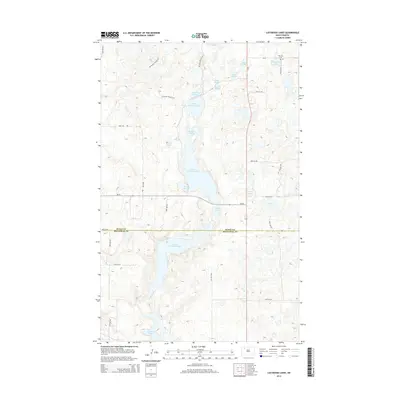
2014 Map of Lostwood Lakes
USGS Topo · Published 2014About this map
Upper Lostwood Lake and Lower Lostwood Lake anchor a landscape defined by an intricate network of wetlands on the border of Burke and Mountrail Counties. This prairie pothole region is characterized by dozens of small, named water bodies such as Dead Dog Slough, Merrills Slough, and Kittelson Slough, which dominate the local topography. In the northeast corner, the Vanville Cem near Martinsen Lake serves as a primary marker of local heritage, while the National Hiking Trail winds through the western hills, offering a rare recreational path through the glaciated terrain. The map records a sparse road network, including ND-50 and ND-8, connecting the scattered farmsteads and lakes in this specialized North Dakota ecosystem.
Find a feature on this map
33 named features on this map. Tap any name to fly to it.
Don’t see what you’re looking for? This feature index may not catch every label — zoom into the map to look around manually.
Map Details
Editions of this 2014 Lostwood Lakes Map
This is the sole edition of this map. No revisions or reprints were ever made.
Other maps of this area

1948 · Vanville NE
USGS Topo · 1:24,000

1950 · Vanville NE
USGS Topo · 1:24,000

1953 · Williston
USGS Topo · 1:250,000

1957 · Williston
USGS Topo · 1:250,000
1974 · Thompson Lake
USGS Topo · 1:24,000
1974 · Helde Lake
USGS Topo · 1:24,000

1974 · Lostwood Lakes
USGS Topo · 1:24,000

1978 · Westby Lake
USGS Topo · 1:24,000
1978 · Lunds Valley
USGS Topo · 1:24,000

1981 · Lostwood
USGS Topo · 1:24,000